Google Play


$255,000,000 MXN
For Sale
Industrial Lot in Perez de Galeana, Apaxco
Venta de Terreno en Apaxco, Perez Galeana
$255,000,000 MXN
for sale
Industrial land in Perez de Galeana, Apaxco
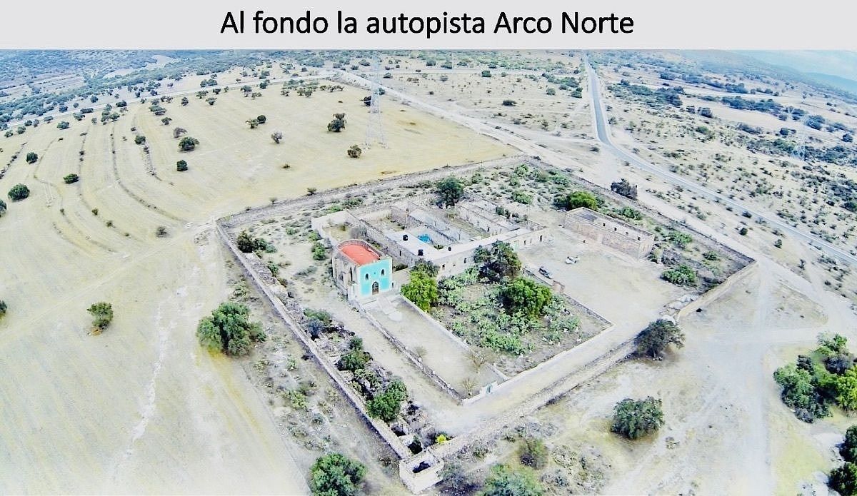
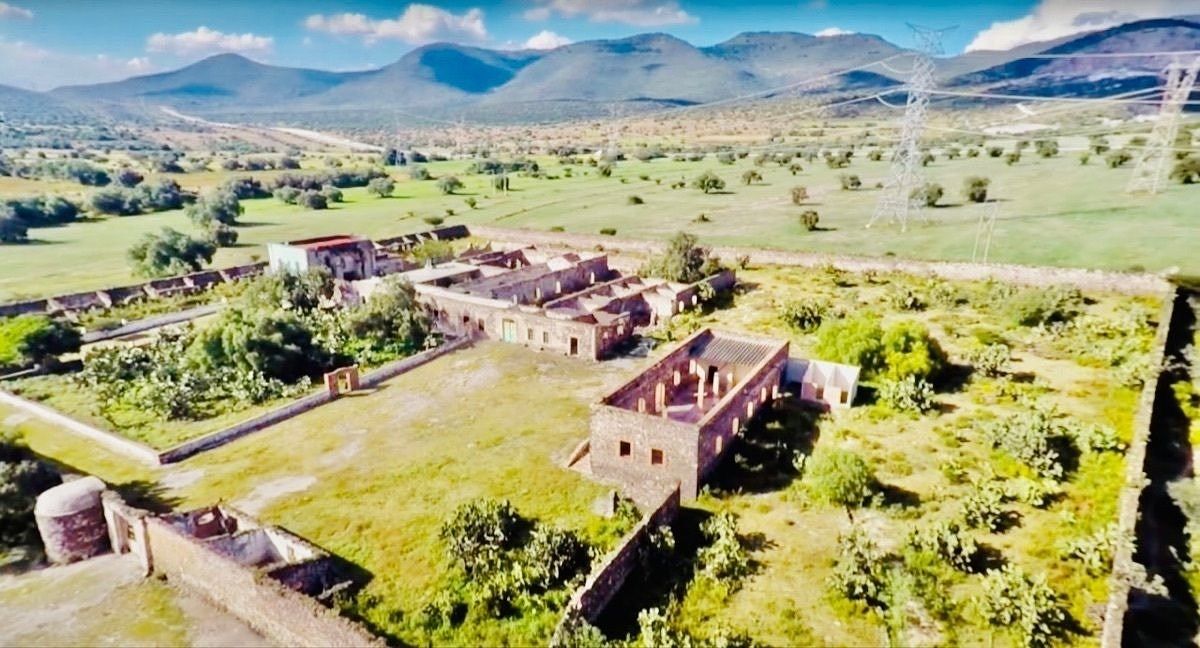
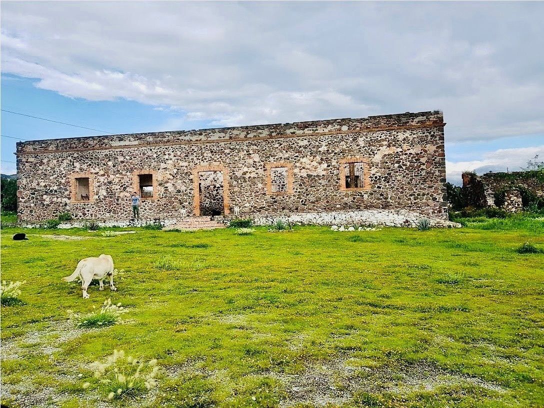
COLONIAL HACIENDA
Main house with central patio
Chapel with continuous arch
Stables
Multipurpose house
Central walling
Perimeter wall
Potential to restore and rebuild
The beamed ceilings are no longer there
PROPERTY:
Private (Not ejido)
WHERE:
Apaxco de Ocampo, State of Mexico.
LOCATION:
In the municipality of Apaxco,
Next to the Cement Factory,
It is crossed by the Arco Norte highway
That comes from Querétaro to Puebla,
Very close to Tula Hgo,
It is 1 hour from Querétaro,
1 hour from Pachuca Hgo,
1 hour from D.F., 1.30 hours from Puebla
REGIONAL ENVIRONMENT:
It is 20 minutes from the Liverpool warehouses,
Even to reach the property
You pass by the mentioned warehouses.
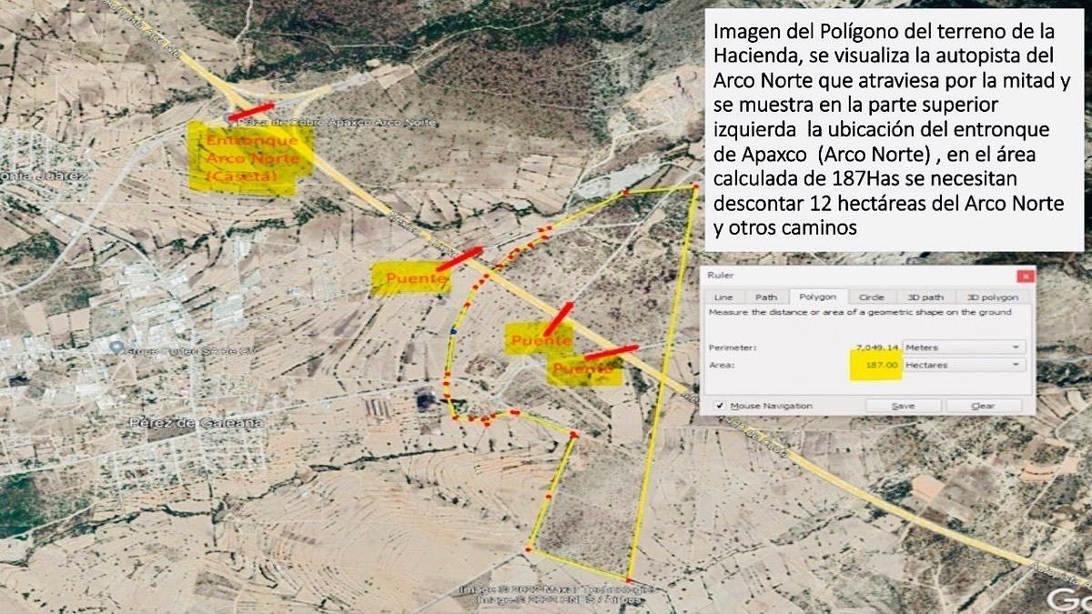
SURFACE:
179 Hectares
- Subtract 12 hectares from Arco Norte, and
- 30 hectares of right of way by CFE
COMPOSITION:
- Highway "Arco Norte" divides the land into 2 parts
1.- 110has south side
2.- 69has north side
LAND USE:
Agricultural
New municipal urban development plan
Where industrial land use changes
Mixed,
Commercial, residential, industrial,
Logistics distribution center
Master Plan Project
PROJECT ALTERNATIVES
I feel it is an excellent option
For real estate housing development,
Logistics distribution center.
CONSTRUCTION
Hacienda shell from the mid-18th century (Can be sold separately) - Preserves original ancient characteristics - Perimeter wall of 5m height
- 10 roofed bedrooms with slab,
- Many more without a roof
- Church with dome roof - -
- Water cistern of 110K liters
ACCESS ROADS:
- Arco Norte highway divides the land in half - Junction to Arco Norte for Apaxco 1.5 Km - Junction Arco Norte in Santa Maria Ajoloapan 9km (Approx. 10 min.) By Perez de Galeana - Sta Ma, Ajoloapan road
- 13km from Atitalaquia via Arco Norte highway - 15 min from Tequixquiac road leads directly
- 30 min from Zumpango Distance from: - Torre Petróleos (Periférico-Reforma) 68Km(1hr)
- Indios Verdes via Zumpango 66Km 90 mins
PRICE:
Negotiable based on hectares and location. Base of $ 142/m2
ALTERNATIVES
Everything or a fraction could be negotiated,
FEASIBILITIES:
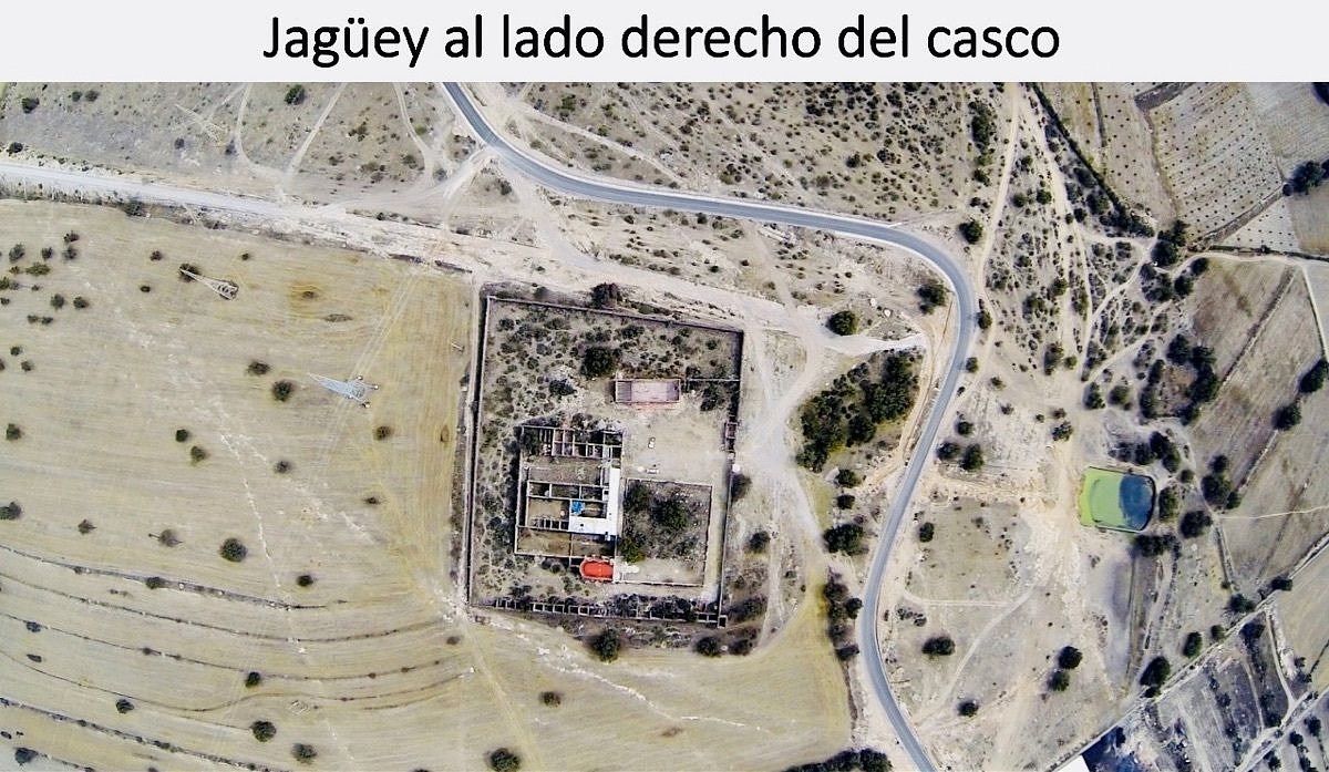
- Deep water well (Belongs to the municipality) - 100m from the shell, on land donated by Hacienda - In the shell, water intake of 1 1/2 inches - 4 lines of high voltage power towers cross the land.
- (Right of way with CFE for 30has) - Jaguey of 50m x 35m
- Flat land
CHARACTERISTICS
a) Certificate of inaffectability
Issued by presidential decree and
Published in the official newspaper of the nation
Dated June 12, 1940.
b) Arco Norte highway crosses along 1.1km
c) Within the Hacienda land,
- 2 vehicular bridges cross "Arco Norte"
- Next to the well, an electric line of 23 thousand Volts arrives, where it connects low voltage energy to the land.
- 2 more vehicular bridges on each side of the Hacienda land that cross Arco Norte.
Which are located on ejido land and
Lead to the town of Perez de Galeana .8Km from the hacienda,
One of them enters Hacienda land.
FUTURE MOBILITY
There will be another road that will pass near the land
That will connect to Zumpango via Arco Norte.
CROSSROADS
It is the passage from the U.S. and the North
Or to the state of Hidalgo and the Port of Veracruz
NEXT MOBILITY
Next access 500 m from the land,
Access to the "Arco Norte" superhighway funded by the cement factory and neighbors.$255,000,000 MXN
en venta
Terreno industrial en Perez de Galeana, Apaxco
HACIENDA COLONIAL
Casa principal con patio central
Capilla de arco de cañon corrido contigua
Caballerizas
Casa uso multiple
Amurrallamiento central
Muralla perimetral
Potencial a restaurar y reconstruir
Los techos envigados ya no estan
PROPIEDAD:
Particular (No ejido)
DONDE:
Apaxco de Ocampo, Estado de Mexico.
UBICACIÓN:
En el municipio de Apaxco,
Junto a la Cementera,
Lo atraviesa la carreta Arco Norte
Que viene de Querétaro a Puebla,
Muy cerca de Tula Hgo,
Está a 1 h de Querétaro,
A 1h de Pachuca Hgo,
A 1 h del D.F., 1.30 h de Puebla
ENTORNO REGIONAL:
Está a 20 min las bodegas de Liverpool,
Inclusive para llegar al predio
Se pasa por las bodegas mencionadas.
SUPERFICIE:
179 Hectáreas
- Descontar 12 hectáreas del Arco Norte, y
- 30 hectáreas de derecho de paso por CFE
COMFORMACIÓN:
- Autopista “Arco Norte” divide terreno en 2 partes
1.- 110has lado sur
2.- 69has lado norte
USO DE SUELO:
Agrícola
Nuevo plan de desarrollo urbano Municipal
Donde cambia uso de suelo industrial
Mixto,
Comercial, habitacional, industrial,
Centro logístico de distribución
Master Plan Proyect
ALTERNATIVAS DE PROYECTOS
Siento una excelente opción
Para desarrollo inmobiliario de vivienda,
Centro Logisitico de distribución.
CONSTRUCCIÓN
Casco de hacienda de mediados del siglo XVIII (Puede venderse por separado) - Conserva características originales antiguas - Muro perimetral de 5m altura
- 10 recamaras techadas con loza,
- Muchas mas sin techo
- Iglesia con techo de cúpula - -
- Cisterna de agua de 110K litros
VÍAS DE ACCESO:
-Autopista Arco Norte divide el terreno a la mitad -Entronque al Arco Norte para Apaxco a 1.5 Km -Entronque Arco Norte en Santa Maria Ajoloapan a 9km (10 min Aprox.) Por carretera Perez de Galeana - Sta Ma, Ajoloapan
- A 13km de Atitalaquia por autopista Arco Norte - A 15 min de Tequixquiac carretera lleva directo
-A 30 min de ZumpangoDistancia desde: - Torre Petróleos (Periférico-Reforma) 68Km(1hr)
- Indios Verdes por Zumpango 66Km 90 mins
PRECIO:
Negociable en base a hectáreas y ubicación. Base de $ 142/m2
ALTERNATIVAS
Todo o se podría negociar una fracción,
FACTIBILIDADES:
-Pozo profundo de agua (Pertenece al municipio) - A 100m de casco, en Predio donado x Hacienda - En casco toma de agua de 1 1/2 pulgadas - 4 Lineas de torres de energía eléctrica
De alta tensión cruzan por el terreno.
- (Servidumbre de paso con CFE por 30has) - Jaguey de 50m x 35m
- Terreno plano
CARACTERÍSTICAS
a) Certificado de inafectabilidad
Emitido por Decreto presidencial y
Publicado en el diario oficial de la nación
Con fecha 12 de Junio de 1940.
b) Autopista Arco Norte cruza a lo largo de 1.1km
c) Dentro del terreno de la Hacienda,
- 2 puentes vehiculares cruzan “Arco Norte”
- Junto al pozo llega línea eléctrica de 23mil Volts, Donde conecta energía de bajo voltaje al terreno.
-2 puentes vehiculares más a cada lado del predio De la Hacienda que cruzan el Arco Norte.
Los cuales se ubican en terrenos ejidales y
Lleva pueblo Perez de Galeana .8Km de hacienda,
Uno de ellos entra a terrenos de la Hacienda.
MOVILIDAD FUTURA
Habrá otra carretera que pasará cerca del terreno Que conectará a Zumpango por Arco Norte.
CRUCE DE CAMINOS
Es el paso desde E.U. y El Norte
O al estado de Hidalgoy Puerto de Veracruz
MOVILIDAD PROXIMA
Próximo acceso a 500 m del terreno,
El acceso a la supercarretera "Arco Norte" sufragado por la cementera y vecinos.
Publisher
Inmuebles Hahn
Listing Data
- Listing ID EB-VA5015
- Operation Type Sale
- Property Type Industrial Lot
- Neighborhood Perez de Galeana
- Postal Code 55665

