Google Play


Timucuy is a municipality that, located in the north central area of the state, belonged to the so-called henequenera zone of Yucatán because its lands have an agricultural vocation for the cultivation of agave. Along with the surrounding municipalities, it was dedicated for many years until the end of the 20th century to the henequen industry as its main productive activity.
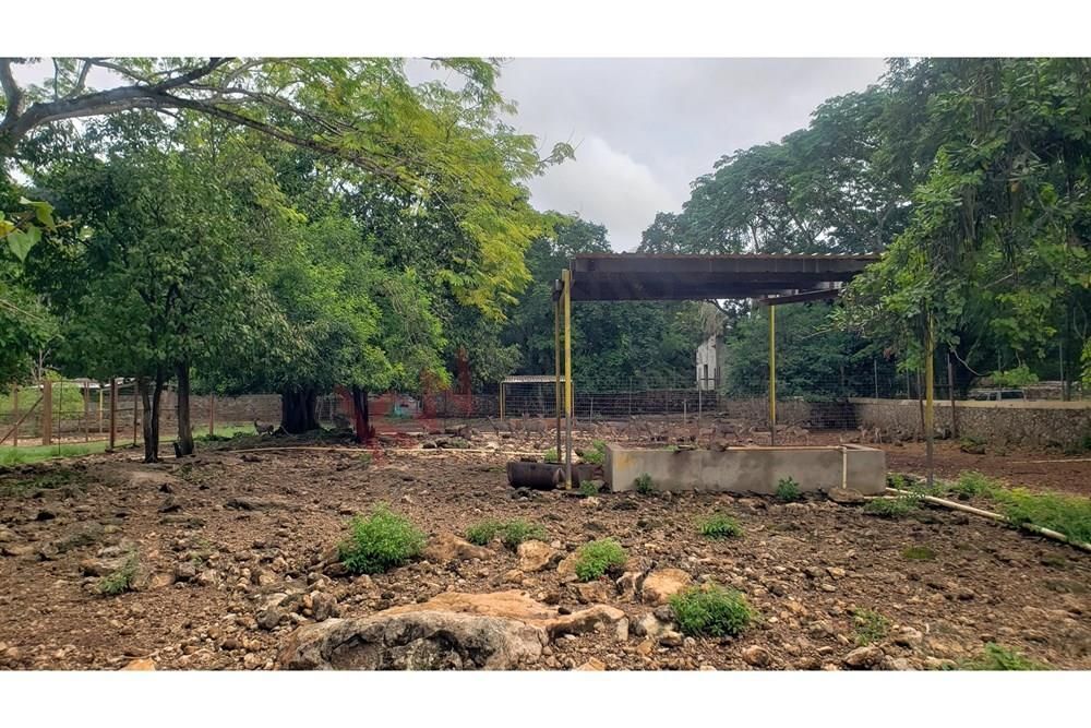
The land is located in the town of Timucuy with a size of 37.3 hectares. It has wildlife conservation management units (UMA) for venison and “Mexican pelon” pork with the corresponding permits from SAGARPA. Seasonal vegetation, secondary vegetation with fruit trees of zapote, huaya, pitaya, ramón, mandarin, grapefruit, mamey. 2 norias found in the first aquifer, at a depth of 9 to 11 meters, 4 deep wells, of which 3 are in the second aquifer mantle and one in the third mantle, have a concession from Conagua, a large part of the land can be suitable for planting habanero pepper. The land has been developed for 20 years. At one time it was a production area for henequén. It has 2 small buildings, one as a room and the other as a warehouse. It has electricity.
It is close to the Teya Mayan train station, approximately 6 kilometers away, the exit to the super highway to Chetumal 4 kilometers away, close to the Kuxtal reserve, as well as to the Tekal de Regil farm just 5 kilometers away, the towns of Acanche and Tecoh 6 kilometers away, the land is located on the important route of the cenote rings.Timucuy es un municipio que, ubicado en la zona central norte del estado perteneció a la denominada zona henequenera de Yucatán porque sus tierras tienen la vocación agrícola para el cultivo del agave. Junto con los municipios circunvecinos se dedicó por muchos años hasta finales del siglo xx a la industria henequenera como principal actividad productiva.
El terreno se encuentra localizado en el poblado de Timucuy con una dimensión de 37.3 hectáreas. Cuenta con unidades de manejo para la conservación de la vida silvestre (UMA) de venado y cerdo "pelón mexicano" con los correspondientes permisos de SAGARPA. Vegetación de temporada, vegetación secundaria con árboles frutales de zapote, huaya, pitaya, ramón, mandarina, toronja, mamey. 2 norias que se encuentran en el primer manto acuífero, en una profundidad de 9 a 11 metros, 4 pozos profundos, de los cuales 3 se encuentran en el segundo manto acuífero y uno en el tercer manto, cuentan con concesión de Conagua una gran parte del terreno puede ser propicio para siembra de chile habanero. El terreno ha sido fomentado por 20 años. En algún tiempo fue zona de producción de henequén. Cuenta con 2 pequeñas de construcción una como estancia y otra como bodega. Cuenta con electricidad.
Tiene cercanía a la estación teya del tren maya, aproximadamente a 6 kilómetros de distancia, salida a la súper carretera a Chetumal a 4 kilómetros, cercano a la reserva de Kuxtal, de igual manera a la hacienda Tekal de Regil a escasos 5 kilómetros, a los poblados de acanche y Tecoh a 6 kilómetros, el terreno se encuentra en la importante ruta de los anillos de cenotes.


By continuing, I agree to the Terms of Service and Privacy Policy.


