Google Play


RESIDENTIAL LAND FOR SALE CALIMAYA
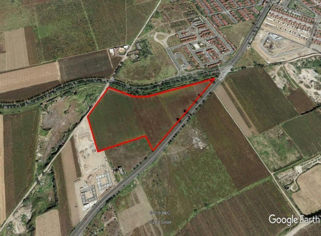
Location: Av. Calimaya, San Andrés Ocotlán, Municipality of Calimaya, Calimaya de Díaz Gonzáles, Mexico.
On the main access road to the municipal seat, 1,830 meters from the Toluca-Tenango highway, 1910'38.45"N 9935'50.67"O
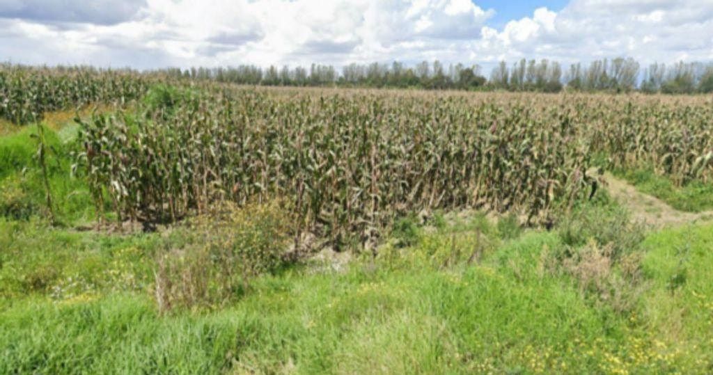
Area: 64,900 m2
It has 350 meters of frontage on the main access to Calimaya, 125 meters at the back on a local road.
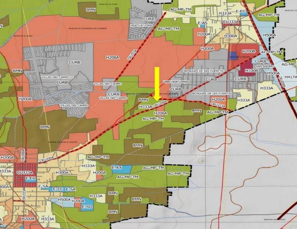
Land Use: it has two land uses, on the roadway (its main access) CRU200A and AGBP (low productivity agricultural).
Property
Price: $3,200 per m2
Observations: it borders on one side with access road to 5 already developed subdivisions and where the construction of at least 6,000 medium-high and high-interest houses is still projected. Added to these homes, there are another 6 subdivisions on the boundary, the municipal seat, the locality of San Andrés, as well as its proximity to other municipalities.
It allows the use of the properties, with a mix of basic and specialized products. A house can be built for every 200 m2 of land. (Raw land).
A maximum height of 2 levels or 6 meters will be allowed without including water tanks from the sidewalk level. Only 70% of the usable land will be allowed to be occupied, leaving the remaining 30% free.
The minimum frontage of the properties must be 120 m, the maximum construction intensity will be 1.4 v.s.p. A proportion of 70% for commerce, services, and equipment must be considered and 30% only for housing.
LOT=200 m
FRONT=7m
HEIGHT 2 LEVELS=6 m
INTENSITY=1.4v.s.p.
% LOT TO BUILD=70%
% FREE AREA=30%
Guillermo Díaz/Jack Kaplan
MAK Corporate Real Estate
NJACK26
WIG: p2oRZSn
PRICES SUBJECT TO CHANGE WITHOUT PRIOR NOTICETERRENO HABITACIONAL EN VENTA CALIMAYA
Ubicación: Av. Calimaya, San Andrés Ocotlán, Municipio de Calimaya, Calimaya de Díaz Gonzáles, México.
Sobre la principal vía de acceso a la cabecera municipal, a 1,830 metros de la carretera Toluca-Tenango, 1910'38.45"N 9935'50.67"O
Superficie: 64,900 m2
Cuenta con 350 metros de frente sobre el acceso principal a Calimaya, 125 metros en la parte trasera sobre camino vecinal.
Uso de Suelo: cuenta con dos usos de suelo, sobre la vialidad (su acceso principal) CRU200A y AGBP (agrícola baja productividad).
Propiedad
Precio: $3,200 por m2
Observaciones: colinda a un costado con vialidad de acceso a 5 fraccionamientos ya desarrollados y donde aún se tiene proyectada la construcción de al menos 6,000 casas de interés medio-alto y alto. Sumadas a esas viviendas se tienen otros 6 fraccionamientos en la colindancia, la cabecera municipal, la localidad de San Andrés, así como su cercanía con otros municipios.
Permite aprovechamiento de los predios, con mezcla de productos básicos y especializados. Se podrá construir una vivienda por cada 200 m2de terreno. (Terreno bruto).
Se permitirá un máximo de altura de 2 niveles o 6 metros sin incluir tinacos a partir del nivel de banqueta. Sólo se permitirá la ocupación del 70% del predio útil debiendo dejar libre el 30% restante.
El frente mínimo de los predios deberá de ser de 120 m, la intensidad máxima de construcción será de 1.4 v.s.p. Se deberá considerar una proporción de 70% para comercio, servicios y equipamiento y un 30% sólo para vivienda.
LOTE=200 m
FRENTE=7m
ALTURA 2 NIVEL=6 m
INTENSIDAD=1.4v.s.p.
% LOTE A CONSTRUIR=70%
% ÁREA LIBRE=30%
Guillermo Díaz/Jack Kaplan
MAK Corporativo Inmobiliario
NJACK26
WIG: p2oRZSn
PRECIOS SUJETOS A CAMBIO SIN PREVIO AVISO


By continuing, I agree to the Terms of Service and Privacy Policy.


